Floods in Slovenia: millions of euros worth of damage, for which we are mostly guilty
Hydrogeological disasters in Slovenia account for over 150 million euros of damage a year. And they are often worsened by human interventions as the country has tolerated construction in flood-prone areas for several decades.
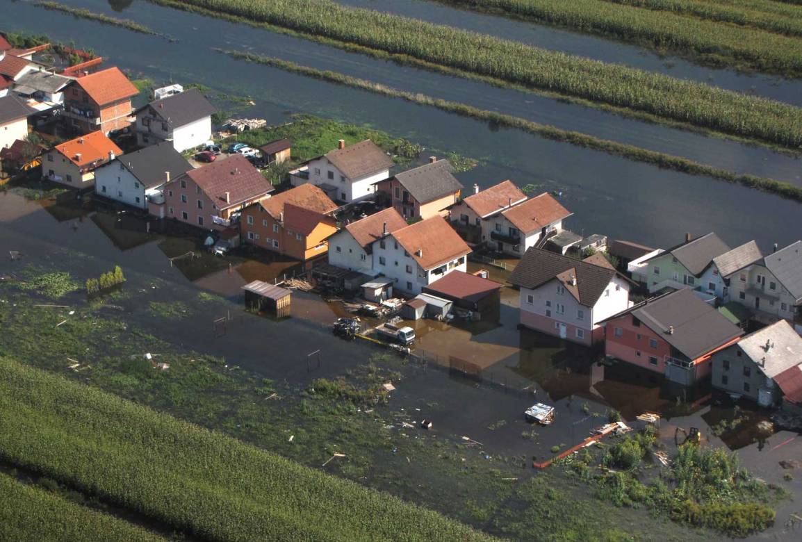
“I did not succeed in putting my boots on. Suddenly, I was kneeling in the water when it hit from the sewer. The water rose very quickly and flooded the ground floor up to a meter. It smelled very much like oil, as the floods in the cellars rolled up tanks with fuel oil. Rats climbed the facade and reached the second floor. It took three days before the water flowed out and I could step into the yard”. This is how Jože, who lives in Ljubljana’s Vrhovci, described us his experience of the flood that happened in 2010.
Their house was also flooded four years later, when other major floods were recorded in Ljubljana. Once again, the water rose very rapidly. Only that it was drained before it caused major damage, owing to the fact that the furnace and electrical appliances were raised by one meter after the rehabilitation of the previous floods. “We have seen that only such adjustments can help us. Even if we had pumps at our disposal, they would not be able to drain so much water, as everything happens within ten minutes,” said the interlocutor.
Among the precautions regarding the floods, the mandatory night on-call services are listed, which are meant to inform about each forecast of major falls. “In the last couple of years, we are exchanging phone calls with our son in the evening and monitoring the data on the flow of water at the measuring stations on the computer or on the mobile phone. We are already aware that action should be taken if the water level at the measuring point Dvor na Gradaščici exceeds a certain limit. At 250-260 centimetres, it is already very critical, and at 220-230 centimetres it is wise to move the cars and prepare the boots,” said Jože. And they hope that in the morning they will not find a parking fine on their cars because of improper parking, because they can only be removed from the sidewalks on a nearby hill.
When the water drains, the inhabitants are waiting for at least two weeks to clean up the flooded dirt and dry the flooded areas. Both floods together caused to Jože a damage amounting to more than ten thousand euros. “After the first floods in 2010, domestic insurance companies were no longer able to insure houses in our neighbourhood. I had to conclude a flood insurance with one of the foreign insurance companies, but I had to take photographs of all the flood prevention embankments and other measures in the area and to submit a lot of documentation to ensure that the area is safe from the usual rainfall,” he added.
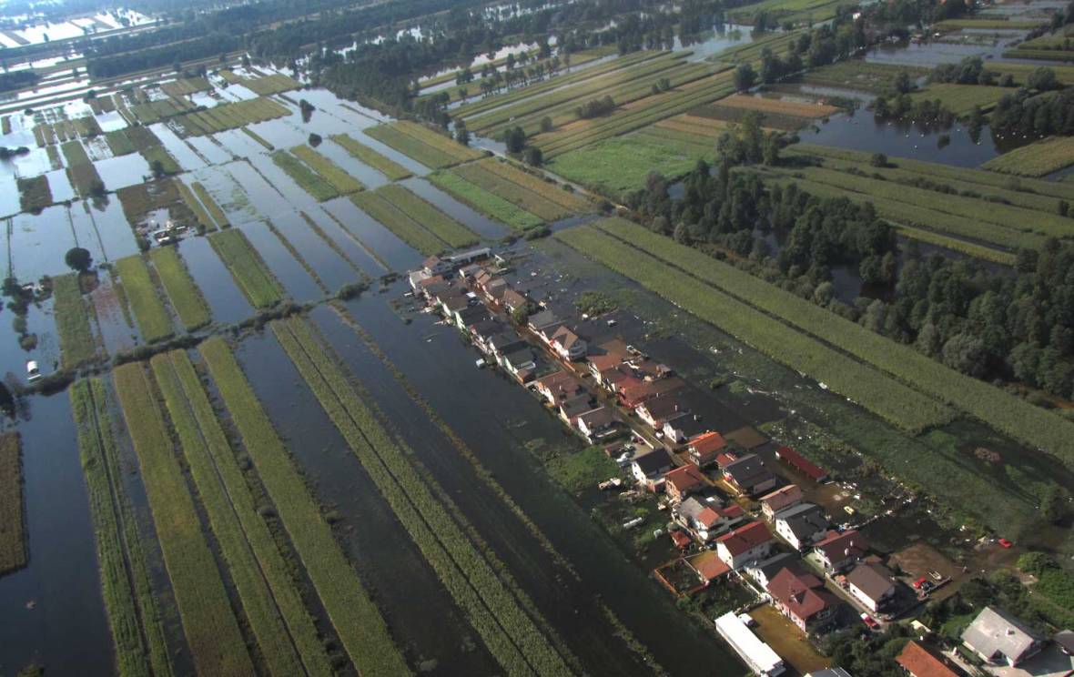
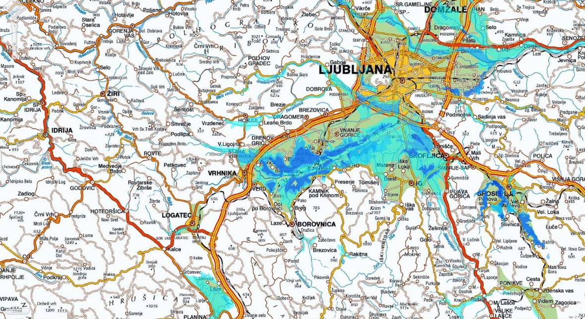
His experience was not the only one, as floods in the autumn of 2010 and 2014 flooded a large part of the southwestern part of Ljubljana. In both cases, there were several factors that increased the impact of the flood. At the Ljubljansko Barje (Ljubljana Marsh), karst flash floods first appeared, occurring several times a year and lasting for several days or weeks. Karst flash floods were accompanied by torrential floods when Gradaščica, Glinščica and Mali Graben rivers rose rapidly due to strong precipitation above the Polhov Gradec dolomites. The water could not be spill-dredged or inflated quickly enough, which was due to the poor maintenance of the flood infrastructure, such as non-flowing canals in which bushes or even trees were growing in some areas.
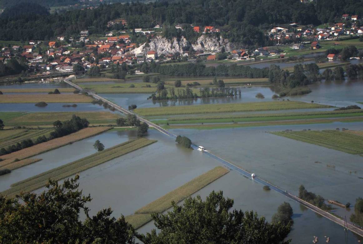
At the National Water Directorate, they told us that the floods in 2010 caused about €190 million of damage. Even more damage was recorded in 2014 (€255 million), and in the last 25 years, the floods swept away about $1.8 billion across the country. Of this, most of the damage has been incurred in the last ten years, as major flood events in 2007, 2009, 2010, 2012 and 2014 caused a billion euros in damages.
In the last decade, floods have caused about €120 millions of damages each year on average, they estimate at the Directorate. If direct damage is added to indirect damage – loss of revenue from economic operators, business collapse, interrupted infrastructure and communication links and other long-term consequences – the annual estimate increases to around €150 million. In the period of 1991-2008, direct damage caused by floods reached almost half of the total GDP each year, according to the researchers of the Geographical Institute at ZRC SAZU Matija Zorn and Blaž Komac – which means approximately €800 per capita alltogether.
In a joint investigation on global warming in European cities, which we carried out this year with EDJNet, we showed that the average temperatures in Slovenia increased compared to the pre-industrial era. Due to higher temperatures, not only droughts and heat waves that were presented in the previous article will escalate, but strong local floods will also intensify, which will cause more frequent and stronger floods across the country, as well as in the two largest cities of Ljubljana and Maribor.
The damage caused by stronger storms and floods will increase in the future, as the state has neglected the maintenance of flood infrastructure in recent decades, and municipal and local administrations have repeatedly issued permission for construction in floodplains and legalized unauthorised construction. An increased risk will be caused by changes in the rainfall and water regime, as the floods will also affect the areas that were not considered to be flooded and do not have adequate flood infrastructure.
Floods will be stronger and more frequent
On 20 November this year, the Slovenian Environmental Agency (ARSO) presented the first results of the project on climate change assessment in the 21st century . Representatives of the Ministry of Environment and ARSO said, inter alia, that the measurements already show a significant increase in ambient air temperature, changes in precipitation occurrences, and more frequent and more intense extreme weather events.
As a result, the annual rainfall level will increase considerably by the mid-21st century: up to 20% compared to the 1981-2010 period, most notably in the winter period and particularly in the east of the country. Already in the middle of the century, winter rainfall in eastern Slovenia will increase to 40 percent, and by the end of the century, the amount of winter precipitation may also rise above 60 percent. It has also been announced that the magnitude and frequency of extreme precipitation will increase.
“If we look at our forecast in an optimistic way, then Slovenia will probably not run out of drinking water until the end of the century,” said Janez Polajnar, head of the Hydrological Forecasting Department at the ARSO. “Less encouraging is the fact that at all measuring stations we recorded an increased height of watercourses at extreme weather events, which means a greater burden on water infrastructure and a higher likelihood of flooding – even in areas where we have not got used to up to now”.
The second major change will be the rise of the sea level – which has risen by 20cm over the last 30 years – which will not only flood the streets in coastal towns, but will also severely burden the sewer system, explained Polajnar. The same problem arises for inland waterways, since sewage cannot absorb many meteoric waters with heavy falls – which has been felt in Ljubljana many times over the years when water flooded the subways and waterways around the city.
More severe floods will be influenced by the warming of the Adriatic Sea, such as in the Kvarner Bay, where storms of high energy will be created more often that will be taken by the winds to the north or northeast. The last such example was the recent floods in Jelendol near Tržič. “The southern wind was very strong for a few days, and it was caught in the Košuta Valley. This caused very intense precipitation, erosion of the riverbed and destruction around the valley” explained Polajnar, adding that similar events in Slovenia will increase as a result of its geographical location and territory.
Polajnar thinks that we are mostly guilty ourselves for the increasing flood risk, because in the past we did not take nature into account. “Sometimes water flooded uninhabited areas and now floods these areas in a harmful way. The biggest problem is the settlement policy. Until the Second World War, Slovenia was an agrarian society. After the war, intensive deagrarisation followed resulting in the increase in cities and settlements, which were often built along river beds. “Why? Due to lobbying of some investors, over-confidence in building flood prevention measures and the loss of historical memory,” the main hydrologist at the ARSO is convinced.
The last major floods were recorded between the two world wars in 1926 and 1933. Then, until the 1990s, we had a relatively dry period, so people forgot about the experiences of their ancestors and massively inhabited the floodplains. When cities expanded and the residents settled in the new residential neighbourhoods, they did not even think that they were living in a risky floodplain. This was confirmed by Jože, who moved to Vrhovce with his family in the 1970s. “Otherwise, I knew that we were living on the edge of the Ljubljansko Barje (Ljubljana Marshes), but the area was considered safe because it was already drying up with the installed canals and embankments. We had all the permits and insurance, and we did not even think about the floods.”
Built in flood zones
In the past, people took more account of natural limitations, Igor Žiberna, a geographer, believes. We knew that in addition to the gorges of the rivers, the floodplains adjacent to the watercourses also belong to the rivers. Extensive forms of land use (logs, pastures) were predominant there, while for fields, settlements and communications we selected higher locations that were not within the reach of the floods.
With the transition from a predominantly agrarian to an industrial society, the concentration of population and the transfer of human activities to the bottom of the valleys and basins, the use of flooded land began to change rapidly. This process has been further accelerated since the independence, as flood zones have become interesting for many public and private investors, who have identified potential (low-cost) lands for new residential neighbourhoods and craft industrial zones. At the same time, people abandoned the former agricultural lands, which not only led to environmental degradation, overgrowing and afforestation (all of which affect the watercourses), but also to construction on former meadows and fields.
Ziberno was therefore interested in how the land use in floodplains actually changed and what kind of potential damage would be caused by floods due to inadequate spatial planning. For the analysis, he selected areas with a great flood risk (OVPN): Ljubljansko Barje along the Ljubljanica, Krško-Brežiško polje along the Sava River, the area between Malečnik and Ptuj near the Drava and the lower Vipava and Mura rivers along the Slovenian-Croatian border. In the Land Use Survey on the OVPN, however, he found that in the years 2000-2014, the share of built-up areas in which floods caused the greatest damage has increased (the highest number of new buildings has grown on former fields, gardens and meadows).
What is the most worrying is the fact that about half of the built-up areas have been rebuilt, despite the publicly announced flood maps and clear warnings following the past floods, told me Žiberna. The inadequate use of soil further increases the damage caused by annual natural disasters. Irresponsible environmental planning will also have financial implications. In total, the loss potential of the OVPN in the years 2000-2014 increased by more than €16 million – on over €180 million. Of this, the loss potential of built-up areas increased by almost €28 million, which was estimated by Žiberna in 2014 at over €98 million. This means that the built-up areas account for more than half of all potentially harmful losses, although they account for only about three percent of the entire OVPN (followed by fields and gardens).
A similar study for the Ljubljana Marshes was prepared by Matija Zorn and Maruša Goluža from the Anton Melik Geographical Institute’s Scientific Research Centre SAZU.
In the 1950s and 1960s, the Ljubljansko Barje (Ljubljana Marshes) was very sparsely populated. In the second half of the 1960s, Ljubljana began to expand and the period of major planned and styled settlements began on the marshes. The first large-scale settlement was the construction of the residential settlement Murgle. At the same time, in the Rakova Jelša and along the Road of Dveh Cesarjev (Two Emperors), numerous illegal constructions began to multiply, which were legalized in the 1990s. The number of inhabitants increased from a few thousand to more than 30,000 in the flood-prone part of Ljubljana until the beginning of the new millennium.
Over the past twenty years, the proximity of the city and the relatively low price of land have attracted major investors who have built new residential neighbourhoods. Floods from 2010, therefore, resulted in damage of buildings and other facilities amounting to more than one million euros in the area of the Ljubljansko Barje. Nevertheless, construction continues in the marshes area, found Zorn and Goluža.
In the building cadastre, the changes in the settlements in certain flood risk areas between 2003 and 2015 were compared. Most of the new buildings were built in the area of Črna Vas and along the Ižana Road (the number of inhabitants of Črna Vas has more than doubled since the independence). Some new buildings or groups of new buildings were also found in some other settlements: Iški Vas, Iški, Bevkah, in the villages of Vrbjena and Maten, Lavrica and Vnani Gorice. In total, 157 new buildings in the area of a medium flood risk, 111 buildings in the area of small flood risk and two buildings in the area of high flood risk were listed.
In order to estimate the potential loss, 157 new buildings, which were built in the area covering the landscape park of the Ljubljansko Barje were taken into account, said Maruša Goluža. Of these, 17 buildings do not have a house number, but nine of them have failed to obtain a cadastral value from the real estate register. The cadastral values in the real estate register were also used for a collective assessment of the damage caused by floods to the buildings. They found that the loss potential has increased by €22 million since 2003, although the country has adopted several laws, regulations and strategies to limit construction in flood areas.
Four major factors are responsible for the increase of the flood damage: inadequate spatial planning, lack of control, insufficient insurance policy and frequent loosening of local policies serving the interests of certain construction investors, Matija Zorn believes. “Planning the construction of new buildings as well as issuing building permits in such areas with low flood safety standards is irresponsible. It is the easiest thing to say that we must accept floods and the increasing damage that they will incur due to climate change. At the same time, despite the law on spatial planning and the strategy for the development of spatial settlement, we still have areas that are endangered by natural disasters. Issuance of building permits gives a person a false sense of security as if she/he was building on a safe area. However, no floodplain is completely safe, regardless of various construction measures.”
After the flood, nobody accepts the liability. Not even the official who issued the building permit or approved the change of purpose in the municipal spatial plan, says Zorn acutely. In the Municipality of Ljubljana, the officials replied that they do not have the exact data on the “legal status of all real estates in flood areas”. They also said that the construction of residential buildings in areas of lower or middle flood risk is not inadmissible. Only investors and buyers of real estates must comply with the prescribed counter-measures, which are controlled by state authorities while bearing the conscious risks related to the construction in the floodplains.
Disputed construction permits
Construction in areas with medium and lower flood risk is not prohibited, but under such conditions, investors must anticipate and adopt appropriate flood protection measures: build dams and dry water retainers, select suitable building materials and take care of the floating barriers. If these measures are properly planned, implemented and maintained, buildings will be relatively safe from flooding. One exception to the rule is rare catastrophic floods, which occur every 50 years or 100 years (“century floods”) against which there is no effective protection.
The 100-year catastrophic floods are statistically occurring once every hundred years. This means that every year there is about one percent probability that strong floods will devastate the area of 100-year floods. This may not seem a lot, but a simple probability calculation shows that the probability of such a flood in the next twenty years is about 18%. Twenty years, however, is a short period of time, considering the life span of a building, especially of a building that is supposed to have been built for at least fifty years. So, what motivates investors and buyers to decide on the construction or purchase of a property in the flood zone? And why is it possible to obtain permits for such construction?

There are several reasons for the current building activity in flood areas, said Tomaž Prohinar, Director of the National Water Directorate, which issues recommendations and approvals for construction on aquatic land. After the independence, investors began to buy wetlands and floodplains throughout the country, because they were empty and cheap, and the needs for space were high. After the purchase, they submitted applications for the change of the municipal spatial implementation act in order to turn the degraded land into a building plot. Then they managed to obtain a spatial implementation act and a building permit. “When they had all the papers and consents, they could build things and sell them. If the new owners were to face floods in a few years, this was no longer an issue for the investor,” Prohinar described the former “business model “of construction in flood areas.
The situation improved somewhat after 2008, when the state restricted the construction in flood areas with a flood regulation and imposed stricter conditions. “Stroka tried to stop or at least limit such construction at every step, but it was often not successful,” said the Director of the Water Directorate. There was also a lot of responsibility shifting. If the municipality did not want to deal with the persistent investor, they confirmed the spatial plan all by supposing that the construction would be stopped later by the Directorate.
At the Directorate, they were therefore “confused with claims” because they had to assess the adequacy of the flood protection measures and respond to complaints. These were many, as investors almost always gained positive opinions from designers and ordered their own flood maps and analyses. There have also been cases when the investors illegally built flood dams and, within a few years’ time, ordered the production of floodplain maps to prove that their plot was safe from flooding.
Many of the problems are caused by the old spatial planning documents, because it is almost impossible to change the purpose of a constructible land. Owners are not willing to give up their building blocks and to lose the value of their property. “It is very difficult to reject the building consent for the owner of a building plot who is in possession of all the relevant documents. It is also not easy to reject the consent to build a road to already constructed buildings, although it will have to be constructed over the floodplain. It is even more difficult to interfere with the areas that were built before the preparation of precise flood maps, and owners can claim that they did not even know that they were building or buying in the flood zone,” added the Planning Director at the Neža Kodre Directorate.
In practice, this means that they often have to accept the situation, we learned at the Directorate. They must check if the investor “showed interest and presented the measures” to ensure flood safety. However, they cannot prove that these measures will not be effective, but at the very least, they cannot recommend the construction of building. According to the logic of the situation, the legalisation of illegal construction in the floodplains also works, all of our interlocutors warned us. It was possible to move to an “illegal” (shanty) house, acquire utilities and other connections, and even a house number. After many years of use, however, such entities were mostly legalised.
If you need to obtain a valid permit for each house before you can even move in and get all the connections, it would be easier to perform surveillance while guiding spatial policy and preventing shanty settlement, Tomaž Prohinar is convinced. A major change would also be the compulsory insurance of buildings built in the flood zones, as the cost of risky construction would not have fallen onto taxpayers – much the same as compulsory car insurance before registration.
How likely are such changes? The Geodetic Administration confirmed us that it was possible to obtain a house number until June 1 this year without a valid permit, if the building was registered in the building register or real estate register and was intended for living or performing a business or other activity (while registering buildings, the Geodetic Administration does not verify the legality of construction). After June 1, new buildings require a permit, which cannot be obtained by illegal construction. The exception is “unpretentious buildings” and houses, for which the applicant declares in writing that the building is one-dwelling and inhabited before June 1. At the three largest insurance companies – Triglav, Sava and Adriatic Slovenica – we were told that they do not even sell insurance in the most flood risk areas.
Therefore, the idea of compulsory insurance in flood areas is currently not feasible. The cost of wrong decisions by state officials and private investors, however, is a burden for taxpayers in the aftermath of the floods, as the state guarantees partial compensation for damage in the event of natural disasters.
Half a billion euros aimed at flood measures
The water network can be compared with the blood vessels in the human body, says Janez Polajnar, a hydrologist from the State Environmental Agency. “Imagine how long you would have survived if your right forearm was not interested in what was happening in the palm of your hand, or if one-third of your body would not want to participate in measures to reduce blood cholesterol,” he lamentingly described the Slovenian spatial policy.
According to the majority of our interlocutors, such “cooperation” is responsible for a large part of the damage caused by floods in the last ten years. An individual municipality or residential neighbourhood has built flood dams or barriers that have exacerbated the situation for residents settled in lower areas. Some municipalities have recklessly altered environmental plans due to individual requests of persistent local investors. Watercourses additionally sewed the sediments that the water brought from the surrounding forests (felled trees, wrongly placed stacks of logs…). Municipalities and state institutions were negotiating about who should take care of the flood infrastructure: maintain the ditches, clean the canals and mow the grass at water retainers. And it was also negotiated about who should pay the damages and pay for the flooding measures.
At the Ministry of the Environment and Spatial Planning, the Water Directorate and the Municipality of Ljubljana, we therefore inquired which flood measures would mitigate the effects of future floods.
The Municipality of Ljubljana reported that from October 2010 to the end of 2014 (after the first floods) “a number of measures to increase the flood safety” were carried out and a total of more than €10 million was earmarked for this purpose (the state has compensated less than €200,000 of this, and contributed a good €2 million for the rehabilitation and maintenance of watercourses from the state’s jurisdiction). But after the floods in 2014, the municipality once again received criticism for having done too little to improve the flood safety.
In the period 2015-2017, the most abandoned trenches and drainage canals were cleaned, flood studies were elaborated and land was acquired for the construction of the dry reservoir Brdnikova, where the first phase of construction was prepared in 2017 (a total of €4 million were allocated for the above measures). This year, another €2.5 million were earmarked for the second phase of the restraining arrangement on Brdnikova Street, the cleaning of drains and canals, and for the production of flood hazard maps (additional €1.9 million were foreseen for future flood protection measures in the development plan). They also responded to support the coordination of local communities in planning flood protection measures and all measures of neighbouring municipalities that improve the situation in the Municipality of Ljubljana (cleaning the gravel retention area in Strahomer, removing the gravel deposits in the Iška river…). However, such coordination being primarily the task of the Directorate for Water, consider the representatives of the Municipality of Ljubljana.
The Ministry of the Environment has announced that measures and projects to manage or to reduce the effects of floods have been identified in the plan. The plan envisaged the most important twenty construction and non-construction measures to prevent floods (control and information systems, adaptation of land use in the river basins…) and identified 61 areas which can be significantly impacted by flood across the country. They will have to report to the government every two years on the implementation of these measures, and the spending of approximately €540 million is planned for 2017-2021 (of which approximately €400 million is estimated to be realistic).
Despite these measures, residents of flood-affected areas will have to adapt to the life with floods, our interlocutors believe. Or move elsewhere.
Living with floods
This year, the Ljubljana Museum of Architecture and Design (MAO) has organised an exhibition about life at the Ljubljana Marshes , where they presented the history of the settlement bordering Ljubljana from the age of the pile dwellers to present date. The authors of the exhibition have shown that people lived with flood waters for a long time until the engineer’s mind prevailed during the Austro-Hungarian monarchy – and came up with the idea that the marshes can be dried up with appropriate construction measures and could finally tackle the floods.
Today, we are increasingly aware that construction measures are not almighty, acknowledged Janez Polajnar. We also know that water temperatures will change due to higher temperatures, as winter precipitation will no longer be retained in the form of snow, but will flow to the valley and to the river basin. This means that in spring and summer, there will be a penury of water reserves if we do not find a way to stop it – for which the natural wetlands that are large water containers, would be best suited and the most appropriate. Therefore, there will also be a need to think about strategies to allow for more room for flood water that could be held in the floodplain.
As an example of an adjustment to floods, Polajnar described the German city of Passau on the Rhine, where the inhabitants of some parts of the city flooded the ground floor with clean water to prevent the ingress of river water. When the floods run out, water is exhausted and dried by the dwellings adapted to such a regime. Similar adjustments could also be made by us, since the price of such a measure and the damage caused to the facilities would often be significantly lower than the construction of the flood dam. If the dike costs a million euros and protects ten houses, which would have experienced water damage in the event of flooding, some tens of thousands of euros worth of damage could be caused by such a construction, the Director of the Water Directorate Tomaž Prohinar argues. Nonetheless, he agrees that the relocation of the work of the population to other districts is not a very realistic option, although it might be most meaningful in the long run. The reactions of the affected population would be also very critical so as to complain that the state does not to sufficiently ensure their safety.
With half a billion euros, which the state plans to devote to floods by 2021, citizens will also pay the price of reckless spatial planning – for the protection of works that should not exist in floodplains. In addition to new embankments, containers and other measures, the state will have to promote the adaptation to a life with floods. Above all, it is more imperative to control construction in flood risk areas and demand more responsibility (for example, compulsory insurance) from investors (and owners) of risky facilities. Especially because the last decade has shown very clearly that “floods that happen every one hundred years” can happen every few years. And each time they cause hundreds of millions of euros of damage.
Nastanek tega članka ste omogočili bralci z donacijami. Podpri Pod črto
Deli zgodbo 0 komentarjev
Več iz teme: Okolje
Kako dobro skrbimo za naše okolje? Sistematično analiziramo okoljska vprašanja v državi.
Epizoda 43 – Poplave v Sloveniji: Selitve z ogroženih območij
V novi epizodi Pod črto podkasta smo šli v Zgornjo Savinjsko dolino. Preverili smo, kakšno je stanje štiri mesece po …

Fine particles in the air: Ljubljana among the most polluted European cities
Fine particle pollution causes premature births, illness, and, in Slovenia, more than 800 preventable deaths every year.


0 komentarjev